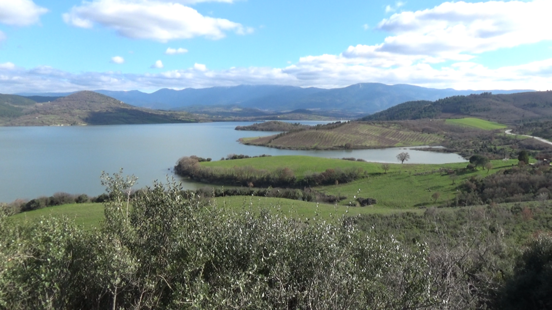
The Bayramiç Dam, known in Turkish as Bayramiç Barajı, is a major reservoir located just a few kilometres east of the town of Bayramiç in north-western Türkiye. Situated in the fertile valley of the Karamenderes River, the dam plays an important role in regulating water supplies and supporting agriculture throughout the surrounding region. The river itself rises in the forested slopes of Kaz Dağları, historically known as Mount Ida, before flowing through the Bayramiç plain and eventually reaching the Aegean Sea near the entrance to the Dardanelles. The reservoir created by the dam has become a distinctive landscape feature in the countryside east of the town and is widely known among local residents for its scenic views and peaceful natural setting.
Construction of the dam formed part of Türkiye’s wider programme of water development projects undertaken during the late twentieth century. The project was carried out by the Turkish State Hydraulic Works authority, State Hydraulic Works (DSİ), which is responsible for the construction and management of dams and irrigation systems throughout the country. Work on the Bayramiç Dam began in 1986 and continued for around a decade before the project was completed in the mid-1990s. The structure itself is an earth-fill embankment dam rising to a height of approximately 56 metres. Its construction required several million cubic metres of rock and soil to create the massive wall that now holds back the waters of the river.
Once completed, the dam created a reservoir with a storage capacity of roughly 86 million cubic metres of water. The lake formed behind the dam extends across several square kilometres of the valley and acts as a strategic reserve of freshwater for the surrounding agricultural districts. The primary purpose of the dam is irrigation, ensuring that farms in the Bayramiç plain have access to water during the long, dry summers typical of the region’s Mediterranean climate. Through a network of canals and irrigation systems, water from the reservoir is distributed to fields and orchards across thousands of hectares of farmland.
Agriculture in this part of Çanakkale Province depends heavily on the water supplied by the reservoir. The fertile soils of the valley support a wide range of crops, including fruit orchards, vegetables, grains and olive groves. Bayramiç in particular is known for its apples and other fruit grown in the rich soils fed by mountain streams descending from the Kaz Dağları. By storing winter rainfall and snowmelt from the mountains, the reservoir allows farmers to maintain reliable crop production even during the driest periods of the year. In this way the dam has become an essential part of the region’s rural economy.
Beyond its agricultural importance, the reservoir has also created a tranquil natural environment that is appreciated by local residents and visitors alike. The surrounding hills and farmland provide attractive views across the water, and the lake has become a quiet spot for fishing and outdoor recreation. Birdlife and freshwater fish species can often be seen around the shoreline, and the peaceful landscape offers a striking contrast to the busy coastal areas nearer to Çanakkale.
The valley flooded by the reservoir also has a long human history. The Karamenderes River was known in antiquity as the Scamander and flowed through a region associated with ancient settlements and routes linking inland Anatolia with the Aegean coast. In recent years, unusually low water levels in the reservoir have occasionally revealed remains of historic structures that once stood in the valley before the dam was built. These discoveries have included the ruins of Byzantine-era buildings, providing a reminder that the fertile lands around Bayramiç have supported communities for many centuries.
Today the Bayramiç Dam remains a vital piece of infrastructure for the region. By regulating the waters of the Karamenderes River and supplying irrigation to a large agricultural area, it continues to support the livelihoods of farmers throughout the valley. At the same time, the reservoir has become part of the natural scenery of the Bayramiç countryside, combining practical function with a calm and attractive landscape shaped by both nature and modern engineering.
Bayramiç Barajı, kuzeybatı Türkiye’de Bayramiç kasabasının sadece birkaç kilometre doğusunda bulunan büyük bir su rezervuarıdır. Verimli Karamenderes River vadisinde yer alan baraj, bölgedeki su kaynaklarının düzenlenmesinde ve çevredeki tarımın desteklenmesinde önemli bir rol oynamaktadır. Nehrin kaynağı ise tarihsel olarak İda Dağı olarak bilinen Kaz Dağları’nın ormanlık yamaçlarıdır. Nehir buradan doğarak Bayramiç Ovası’ndan geçer ve sonunda Çanakkale Boğazı girişine yakın bir noktada Ege Denizi’ne ulaşır. Barajın oluşturduğu rezervuar, kasabanın doğusundaki kırsal alanın belirgin bir manzara unsuru hâline gelmiş ve güzel manzarası ile huzurlu doğal ortamı sayesinde yerel halk arasında iyi bilinen bir yer olmuştur.
Barajın inşası, Türkiye’de 20. yüzyılın sonlarında gerçekleştirilen geniş kapsamlı su geliştirme projelerinin bir parçasıydı. Proje, ülke genelinde barajların ve sulama sistemlerinin inşası ve yönetiminden sorumlu olan State Hydraulic Works (DSİ) tarafından yürütülmüştür. Bayramiç Barajı’nın inşaatı 1986 yılında başlamış ve yaklaşık on yıl sürdükten sonra 1990’lı yılların ortalarında tamamlanmıştır. Barajın kendisi yaklaşık 56 metre yüksekliğe ulaşan bir toprak dolgu barajdır. Bu büyük yapının inşası için milyonlarca metreküp kaya ve toprak kullanılmış ve böylece bugün nehrin sularını tutan devasa baraj gövdesi oluşturulmuştur.
Baraj tamamlandıktan sonra yaklaşık 86 milyon metreküp su depolama kapasitesine sahip bir rezervuar meydana gelmiştir. Barajın arkasında oluşan göl, vadinin birkaç kilometrekarelik alanına yayılmakta ve çevredeki tarım bölgeleri için stratejik bir tatlı su rezervi görevi görmektedir. Barajın temel amacı sulamadır. Bu sayede Bayramiç Ovası’ndaki çiftlikler, bölgenin Akdeniz iklimine özgü uzun ve kurak yaz aylarında suya erişim sağlayabilmektedir. Rezervuardan alınan su, kanallar ve sulama sistemlerinden oluşan bir ağ aracılığıyla binlerce hektarlık tarım arazisindeki tarlalara ve meyve bahçelerine dağıtılmaktadır.
Çanakkale ilinin bu bölümündeki tarım, büyük ölçüde rezervuardan sağlanan suya bağlıdır. Vadinin verimli toprakları meyve bahçeleri, sebzeler, tahıllar ve zeytinlikler dâhil olmak üzere birçok farklı ürünün yetişmesine imkân tanır. Bayramiç özellikle Kaz Dağları’ndan inen dağ dereleriyle beslenen verimli topraklarda yetiştirilen elması ve diğer meyveleriyle tanınmaktadır. Baraj sayesinde kış yağmurları ve dağlardaki kar suları depolanarak yılın en kurak dönemlerinde bile çiftçilerin güvenilir bir şekilde üretim yapabilmesi sağlanır. Bu nedenle baraj, bölgenin kırsal ekonomisinin önemli bir parçası hâline gelmiştir.
Tarım açısından taşıdığı önemin yanı sıra rezervuar, yerel halk ve ziyaretçiler tarafından takdir edilen sakin bir doğal ortam da oluşturmuştur. Çevredeki tepeler ve tarım arazileri göl üzerinde güzel manzaralar sunarken, baraj gölü balık tutmak ve açık havada vakit geçirmek için sessiz ve huzurlu bir yer hâline gelmiştir. Kıyı boyunca kuşlar ve tatlı su balıkları sıklıkla görülebilir ve bu sakin manzara, Çanakkale’ye daha yakın olan yoğun kıyı bölgeleriyle dikkat çekici bir tezat oluşturur.
Rezervuarın suları altında kalan vadi aynı zamanda uzun bir insanlık tarihine sahiptir. Karamenderes River antik çağlarda Scamander adıyla bilinmekteydi ve Anadolu’nun iç kesimleri ile Ege kıyılarını birbirine bağlayan eski yerleşimler ve yolların bulunduğu bir bölgeden geçmekteydi. Son yıllarda rezervuardaki su seviyesinin alışılmadık derecede düştüğü dönemlerde, baraj inşa edilmeden önce vadide bulunan eski yapıların kalıntıları zaman zaman ortaya çıkmıştır. Bu buluntular arasında Bizans dönemine ait yapı kalıntıları da yer almakta olup, Bayramiç çevresindeki verimli toprakların yüzyıllar boyunca topluluklara ev sahipliği yaptığını hatırlatmaktadır.
Günümüzde Bayramiç Barajı bölge için hayati bir altyapı tesisi olmaya devam etmektedir. Karamenderes Nehri’nin sularını düzenleyerek geniş bir tarım alanına sulama sağlayan baraj, vadi boyunca yaşayan çiftçilerin geçimini desteklemektedir. Aynı zamanda rezervuar, Bayramiç kırsalının doğal manzarasının bir parçası hâline gelmiş ve modern mühendislik ile doğanın şekillendirdiği sakin ve etkileyici bir peyzaj oluşturmuştur.




Leave a Reply